Te Wai ā-moe (Crater Lake) heating episode is over at Mt Ruapehu. Volcanic activity remains low, and the Volcanic Alert Level remains at 1.
Te Wai ā-moe (Ruapehu Crater Lake) has started to cool again, marking the end of the heating episode that started mid-October 2023. Temperature is currently 24 °C, down from its peak at 31 ºC on 14 February 2024. Other volcanic monitoring indicators remain within normal ranges and Volcanic activity remains low overall. The Volcanic Alert Level remains at 1 and the Aviation Colour Code at Green.
In mid-October 2023, the temperature of Te Wai ā-moe (Crater Lake) started increasing (Figure 1), peaking at 31 ºC on 14 February 2024. Temperature then began to decrease, marking the end of the heating episode. The lake temperature is now 24 ºC and the calculated heat flow into the lake is currently around 100 MW, typical of periods when the lake is cooling. Earlier in the heating episode the calculated heat flow ranged from 200 to 300 MW.
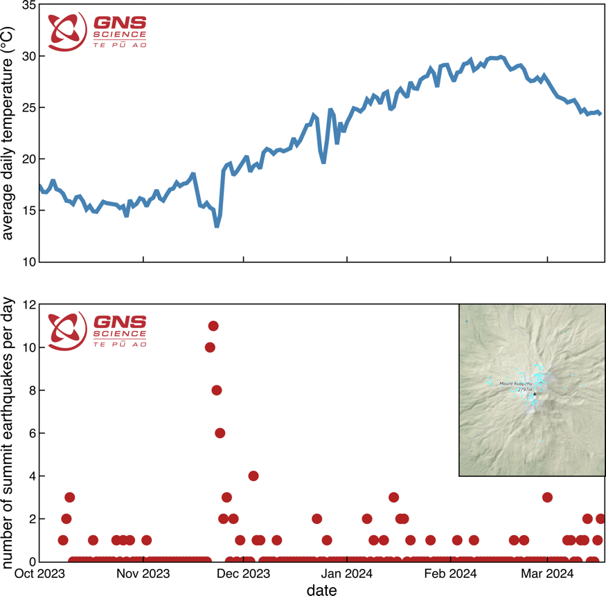
Figure 1: Plot of Te Wai ā-moe (Crater Lake) temperature (top) and number of earthquakes under the summit per day over time, from October 2023 to March 2024 (bottom – see inset for map of earthquake locations).
During the heating episode, our seismic monitoring equipment at Mt Ruapehu recorded a typical sequence of small earthquakes at 3-8 km depth clustered under the volcano (Figure 1). Earthquake size ranged from M0.3 to M2.4. This earthquake activity has continued as the lake cools. Volcanic tremor, a key indicator of volcanic fluid movement, remains low and other monitoring indicators are within normal ranges.
Our scanDOAS gas scanning equipment measured moderate levels of SO2 (sulphur dioxide) gas output from the lake as it warmed, and a slight decline is now apparent as it cools.
The recent earthquakes at moderate depth under the volcano may be in response to a deep volcanic process, however, the other monitoring parameters like volcanic tremor, heat flow, gas flow, and lake surface behaviour are all typical of a heating-cooling episodes in the crater lake. These are driven by shallower processes in the hydrothermal system, typical of the past processes seen in the crater lake. The longer-term lake temperature plot (Figure 2) shows that the last heating episode remains within the range of temperatures recorded over the past five years.
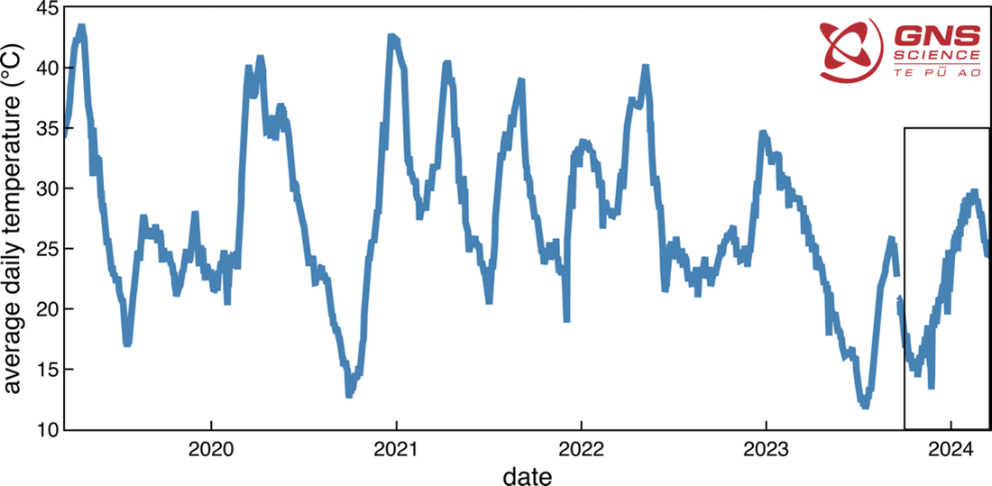
*Figure 2:* Plot of Te Wai ā-moe (Crater Lake) temperature over 5 years, from March 2019 – March 2024. The black box to the right indicates the last 6 months shown in Figure 1.
Overall, all monitoring indicators are consistent with a low level of volcanic activity usually seen during a waning heating episode. As a result, the Volcanic Alert Level remains at 1. The Aviation Colour Code remains Green. Mt Ruapehu is an active volcano and has the potential to erupt with little or no warning when in a state of minor volcanic unrest. The Volcanic Alert Level reflects the current level of volcanic unrest. The Volcanic Alert Level should not be used to forecast future activity.
Volcanic Alert Level 1 indicates the primary hazards are those expected during volcanic unrest: steam discharge, volcanic gas, earthquakes, landslides, and hydrothermal activity. While Volcanic Alert Level 1 is mostly associated with environmental hazards, potential for eruption hazards also exists and eruptions can still occur with little or no warning. Volcanic Alert Levels 3, 4 and 5 are reserved for eruptions with varying impact distances.
For information on access to the Mt Ruapehu area, please visit the Department of Conservation’s website on volcanic risk in Tongariro National Park and follow the DOC Tongariro Facebook page for further updates.
For information about responding to volcanic activity there are guidelines from the National Emergency Management Agency.
https://getready.govt.nz/emergency/volcanic-activity/
GNS Science and its National Geohazards Monitoring Centre continue to closely monitor Mt Ruapehu for further changes.
Cameron Asher
Duty Volcanologist
Media Contact: 021 574 541 or media@gns.cri.nz