Looking back: Three years since triple tsunamis, how frontier science supported NZers return home safely sooner
Three years ago today, 5 March 2021, New Zealand experienced an extraordinary day of three large offshore earthquakes – each one triggering a tsunami threat to coastal dwellers in the North Island.
The first M7.2 quake off East Cape shook New Zealanders awake at 2.28am, prompting a self-evacuation as advised by NEMA’s well-instituted ‘long, strong, get gone’ message.
At 6.41am and 8.28am, two subsequent large earthquakes with magnitudes 7.3 and 8.1 respectively, struck in the Kermadec subduction zone, around 1,000 km northeast of New Zealand. Earthquakes generating in this region, known as regional earthquakes, pose a silent threat as they are too far away to be felt but can trigger large tsunami waves that can arrive within one to three hours. For these earthquakes we rely on sensors in the deep ocean to alert us to potential tsunami danger.
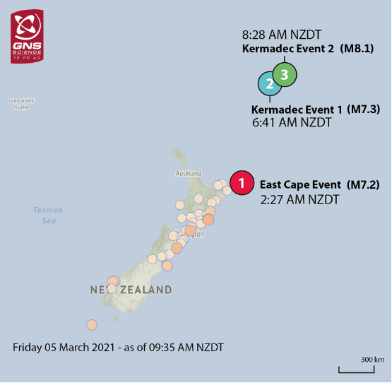
Location, magnitude and time of three large (M7+) offshore earthquakes on 5 March 2021
From the moment the first earthquake hit, GNS’s National Geohazard Monitoring Centre, operated under the GeoNet programme, was monitoring and analysing data from New Zealand’s deep-ocean gauge network (DART buoys) to track the tsunamis and inform expert advice provided to our emergency service partners.
What many may not know about this day, is the frontier science that was rapidly working away to enhance our existing tools to calculate, for the first time, a tsunami forecast that predicted how the waves would progress around the coast for these overlapping events.
Applying new techniques, the GNS Rapid Characterisation of Earthquake and Tsunami (RCET) programme is using data from land, coastal and deep-ocean gauge monitoring to make more targeted critical information about tsunamis available to emergency response agencies faster.
Bill Fry, a seismo tectonophysicist, RCET programme lead and a member of GNS’s Tsunami Expert Panel advising from the Beehive that day, gives an account of how next-generation science joined forces with emergency response to deliver the best possible advice to inform evacuations in at-risk areas.
“Working with our collaborators from the US National Oceanic and Atmospheric Administration, we used measurements transmitted by DART buoys to describe the tsunami source. We then used that information to model the tsunami with high-performance computing from the Beehive bunker – how high would the waves be, when would they arrive and how would they evolve along our coastlines through time,” Dr Fry said.
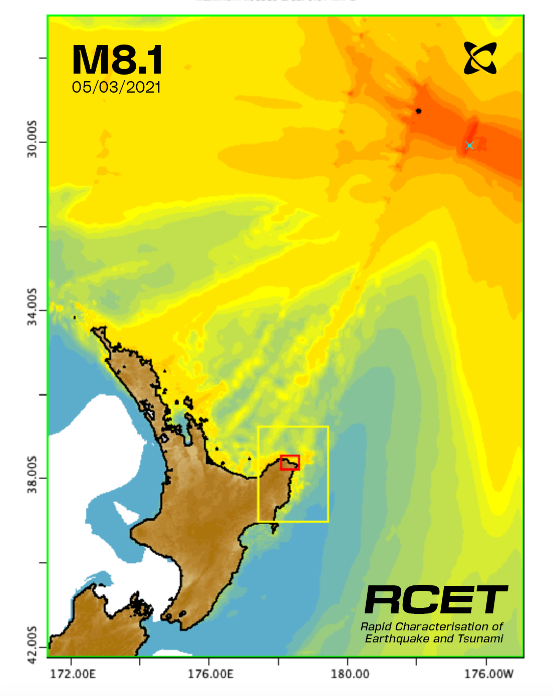
Tsunami forecast before arrival illustrating areas at-risk of wave inundation
“This meant that rather than agonisingly watching coastal tide gauges in real time to observe when tsunami waves had arrived and abated, we could use the most advanced tools developed under the RCET programme to forecast when the waves would subside and people could safely return home.
“We shared this critical information with the National Crisis Management Centre (NCMC) and for the first time ever, New Zealanders were given the all-clear to return home based on our forecast advice, at least four hours earlier than would have been possible following the previous procedure.
“This kind of rapid science to advice to action is often only tested in these high-stake real-life situations. And it is here where the long-standing relationships and trust between scientists and emergency responders makes a difference to people on the ground.”
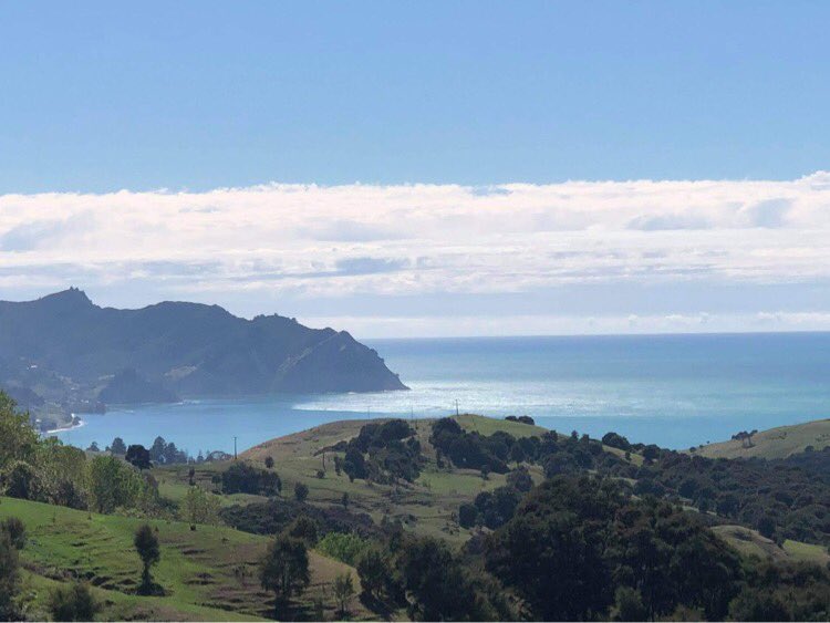
Surges arriving in Tokomaru Bay on the East Cape.
Three years on, the RCET programme has made strides in its research. GNS now has an operational system to compute time-dependent tsunami forecasts entirely locally for the next big event.
The team is also tantalisingly close to expanding the breadth of real-time information to include inundation. In addition to wave height at the shore, this would also tell us how far inland the tsunami waters will likely travel. This valuable nugget of new intelligence could inform more targeted location-specific evacuations and help emergency responders direct their resources to where they are needed most.
RCET is funded by the MBIE Endeavour Fund. Following significant seismic events, RCET’s tools and expertise deliver enhanced rapid science directly to emergency management and to the public, on the GeoNet website.
Make sure you and your whānau are tsunami-ready: • Be prepared and know what to do and where to go should a tsunami warning be issued.
• Learn where the tsunami evacuation zones are for your area and make sure you know where to go to be safe, whether you are at home, at work or out and about. Plan and practise your evacuation route.
• Make sure you know the different ways to stay informed during an emergency. Learn which radio stations to listen to, which websites and social media to follow, and check if you can receive Emergency Mobile Alerts on your mobile phone.
• If you’re in a coastal area, or a lake, and you feel a long or strong earthquake or abnormal movement of the coastal waters, don’t wait for an official warning. Move immediately to the nearest high ground, out of all tsunami evacuation zones, or go as far inland as possible.
Media Contact: 021 574541 or media@gns.cri.nz